Coyote Ridge (and Rimrock Trail) ~5,700
19 April, 2009 Sue Wolber (solo)
After snow Friday and drizzle/overcast Saturday, it was 60F Sunday and I had to get out and hike somewhere. Horsetooth Mountain still had snow on its slopes, so I went back to the lowest trail around - Coyote Ridge/Rimrock. The trail was quite busy, lots of other folks had the same idea :-) There were a lot of prairie rats on the trail (aka box lunches for eagles/hawks, aka prairie dogs)This trail now hooks up with the blue sky trail running from Devil's Backbone in Loveland, north to Horsetooth Mountain Park.
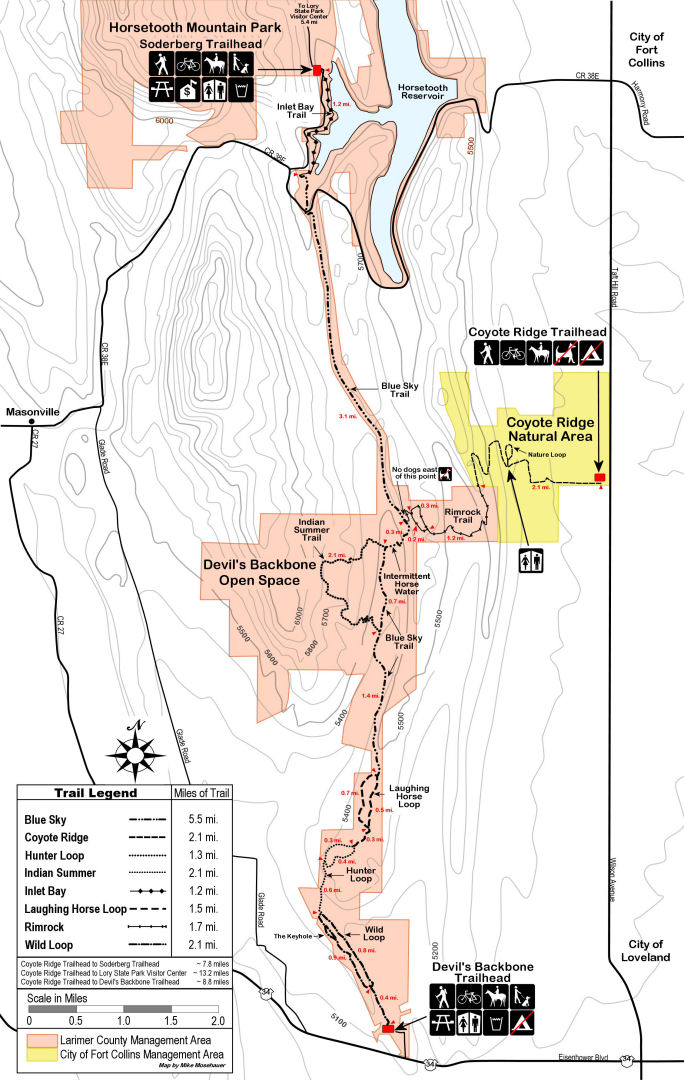
Here's a wonderful map of the area.
Because of the recent snow/rain the trail was quite muddy in spots, but passable. Total time 2:35.
20 July, 2003 Sue Wolber (solo)
Trailhead is ~5,200 - take Wilson aka Taft Hill about 1.5 miles south of the Landfill - between Fort Collins and Loveland and a really short drive from either town - and turn west at the obvious sign. Gobs of parking. Free.
Length one-way: 3.5 miles
Nice sign at the trailhead showing topo map of the trail and where the Coyote Ridge trail technically stops and the Rimrock trail starts. No dogs allowed period. Horseback riders encountered were polite and willing to chat.
I started ~8pm which was way too late (I hadn't realized it was 7 miles round-trip) but it was a nice sunset hike. The first mile is smooth wide road with a gentle up and down grade to the first tiny foothill ridge and down to the bottom of the next ridge. There are bathrooms and a cabin here. Now the trail goes to single-track and winds up and a little down and up the next 2 ridges to the west. A little rocky but gentle grade. Since it was dusk there were deer and bunnies and birds everywhere, but not a mosquito in sight. At mile 2 it changes to the Rimrock trail, which winds a bit then does a steep downhill with steps (very well maintained) down into a rolling meadow, and up the other side to the top of the next ridge. Aside from the steps, through the meadow to the start of the next ridge the trail is completely smooth (not level but smooth -- I can hike and look around instead of looking at the trail to not trip on rocks). Partway up the last ridge the trail forks and loops back around. Total elevation gain is not much, but I was surprised at how much down and back up there was.
I would advise starting before 8pm unless it's a full moon - I needed a flashlight by about 9:30 since there was no moon, though the last mile out on the wide road there was just enough starlight to see by. Upside is there was no scorching sun -- there is no shade on this trail so bring plenty of sunscreen for a daylight hike!
Total time 2:17. Nice very well maintained trail, very short drive away (closer than Horsetooth!).
Back to my hiking page.